We remain fully operational. Our teams are working around the clock to ensure your deliveries continue safely.

Descargar la aplicación


Servicios al cliente
Sobre nosotros
Copyright © 2025 Desertcart Holdings Limited
Descargar la aplicación


Buy anything from 5,000+ international stores. One checkout price. No surprise fees. Join 2M+ shoppers on Desertcart.
Desertcart purchases this item on your behalf and handles shipping, customs, and support to Mexico.
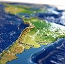
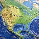
World Ranger 3D Map by Hubbard Scientific | A True Raised Relief Map - You Can Feel the Terrain | Vacuum-formed Molded Map | 36'' x 24'' | Detailed Topography : desertcart.co.uk: Stationery & Office Supplies Review: A family member was trying to understand the location of Egypt — other maps had so much information, including color coding to help one see national boundaries, that it was hard to get oriented. This map shows country boundaries, but the information is primarily about the earth itself — the topography, vegetation, and waters. As a result, one instantly, viscerally, gets a sense of the relations of things — of how dramatic the Himalayas are, and the mountainous west coast of South America. Right away we could see Egypt’s relationship to Africa, the Mediterranean and Europe. It takes more than one kind of map to see an area, but this is an excellent map for starting with the big picture. It’s well-made, too. Just love it! Review: The map is lightweight and has excellent detail. Our grandson is into geography and he loves the map. We were even able to use the map to discuss how the continents moved apart because there is good detail. The product arrived ahead of schedule, well in time for Christmas.


| ASIN | B0CLM8SQ7R |
| Customer reviews | 3.8 3.8 out of 5 stars (27) |
| Dimensions | 91.44 x 60.96 x 0.25 cm |
| Item weight | 249 g |
| Publication date | 1 Jan. 2023 |
| Publisher | HUBBARD SCIENTIFIC |
K**A
A family member was trying to understand the location of Egypt — other maps had so much information, including color coding to help one see national boundaries, that it was hard to get oriented. This map shows country boundaries, but the information is primarily about the earth itself — the topography, vegetation, and waters. As a result, one instantly, viscerally, gets a sense of the relations of things — of how dramatic the Himalayas are, and the mountainous west coast of South America. Right away we could see Egypt’s relationship to Africa, the Mediterranean and Europe. It takes more than one kind of map to see an area, but this is an excellent map for starting with the big picture. It’s well-made, too. Just love it!
I**1
The map is lightweight and has excellent detail. Our grandson is into geography and he loves the map. We were even able to use the map to discuss how the continents moved apart because there is good detail. The product arrived ahead of schedule, well in time for Christmas.
V**I
Worst purchase I made. For the price, I expected much more detail. Mountains are clumped together in 1 chunk. That said, the overall quality is fine, color is very accurate to real world and it fits well in a frame. Perhaps it's my fault expecting more while knowing the size. I guess the price made me expect more.
M**B
The map showed up with holes in it and dents all over. Very poor quality for a $100 map
M**.
It’s a little expensive but the sensory aspect is great for small learners. I would think a more appropriate price would be $70 or less but we did like the look. Can bend easily so you have to be careful when using it.
Trustpilot
Hace 2 semanas
Hace 2 meses